
Almaty, Kazakhstan’s largest city and former capital, is situated near the snow-capped Tian Shan mountains. It has bustling markets, Soviet-era architecture, and a vibrant café scene. The city feels very green and is much cheaper compared to Bishkek, the Kyrgyz capital, from where we had just arrived.
We stayed in Almaty for a week, which was enough to immerse ourselves in the local culture and history. We walked around the city, visited museums, and hired a taxi for day trips. We also took one overnight trip from Almaty. You can find the details of those trips below.
City Highlights
Walking the City Center
You can find many online walking tour recommendations. The city is quite walkable, and ride-share apps are also available for getting around. We enjoy walking wherever we travel, so we explore the area, looking for good coffee shops, bars, breweries, local food, and interesting streets and architecture. As a side note, we rent an Airbnb in a prime location close to most sightseeing spots, and we choose to spend money on a nice Airbnb instead of transportation. We have breakfast at home, eat fruits and salads for lunch, and dine at any good restaurants.
Getting around: For longer distances, we use the Indrive mobile app, which works well. However, we weren’t able to register on Yandex Go—even though we had an eSIM, possibly because it requires a local SIM card. We noticed Yandex Go was the most widely used app there, as of September 2025.
We recommend the following must-see sites in Almati:
Central State Museum of History, Kazakhstan
We always like to start with the history museum, since it gives us an overview of the country. Most importantly, the history museums help us identify the regions with the richest ancient sites, whether ruins or remnants of old cultures. So, we can plan our future trips around them and make sure we don’t miss anything important. The exhibits of the Central State Museum of History, Kazakhstan, range from ancient artifacts and ethnography to modern independence.
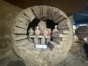
Potter’s Workshop 12th Century
The Almaty Museum has much more to offer than just the city’s history. It includes exhibits on ancient tribes that once lived in the region, such as those from the Saka and Turkic periods, featuring bronze tools, weapons, and burial objects. There are also sections showing Almaty’s role on the Silk Road, with trade goods, coins, and models of caravan routes. A large natural history section displays fossils and petrified animal bones from creatures that roamed the Tien Shan Mountains millions of years ago, along with information about the ancient petroglyph sites of Tamgaly and Tamgaly-Tas.
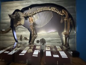
Ancient Mammoth Fossil
We noticed that museums in Central Asia are very well organized, with separate sections that make it easy to follow the flow of history as you walk through. The layout was excellent and thoughtfully designed.
Art Museum of the Republic of Kazakhstan
This recently renovated museum displays national paintings, sculptures, and applied arts. It is the first private contemporary art museum in Central Asia, founded by Nurlan Smagulov, a Kazakh entrepreneur and philanthropist. Smagulov is one of the country’s leading business figures and the founder of Astana Group, established in 1992, which includes Astana Motors, MEGA Center, and MyCar. In 2020, he founded the Nurlan Smagulov Foundation to support education and art. His passion for art led to the creation of this museum, and he has been honored with Kazakhstan’s Kurmet and Order of Barys II awards.
The museum is very well organized, with information available in English, making it easier to appreciate the artwork. The collection not only highlights contemporary artists but also helps visitors understand culture and perspectives—how people are both different and similar to the rest of the world.
Tickets can be purchased online. When we visited, the museum had just opened, so we had to wait until the next day to book our slot. Most of the visitors we saw there were locals.
Green Bazaar aka Zelyony Bazaar
The Green Market is a typical Central Asian bazaar that we love visiting and spending time in wherever we travel, whether it was the Grand Bazaar in Turkey, the bazaar in Karakol, Kyrgyzstan, or the Mehrgan market in Tajikistan.
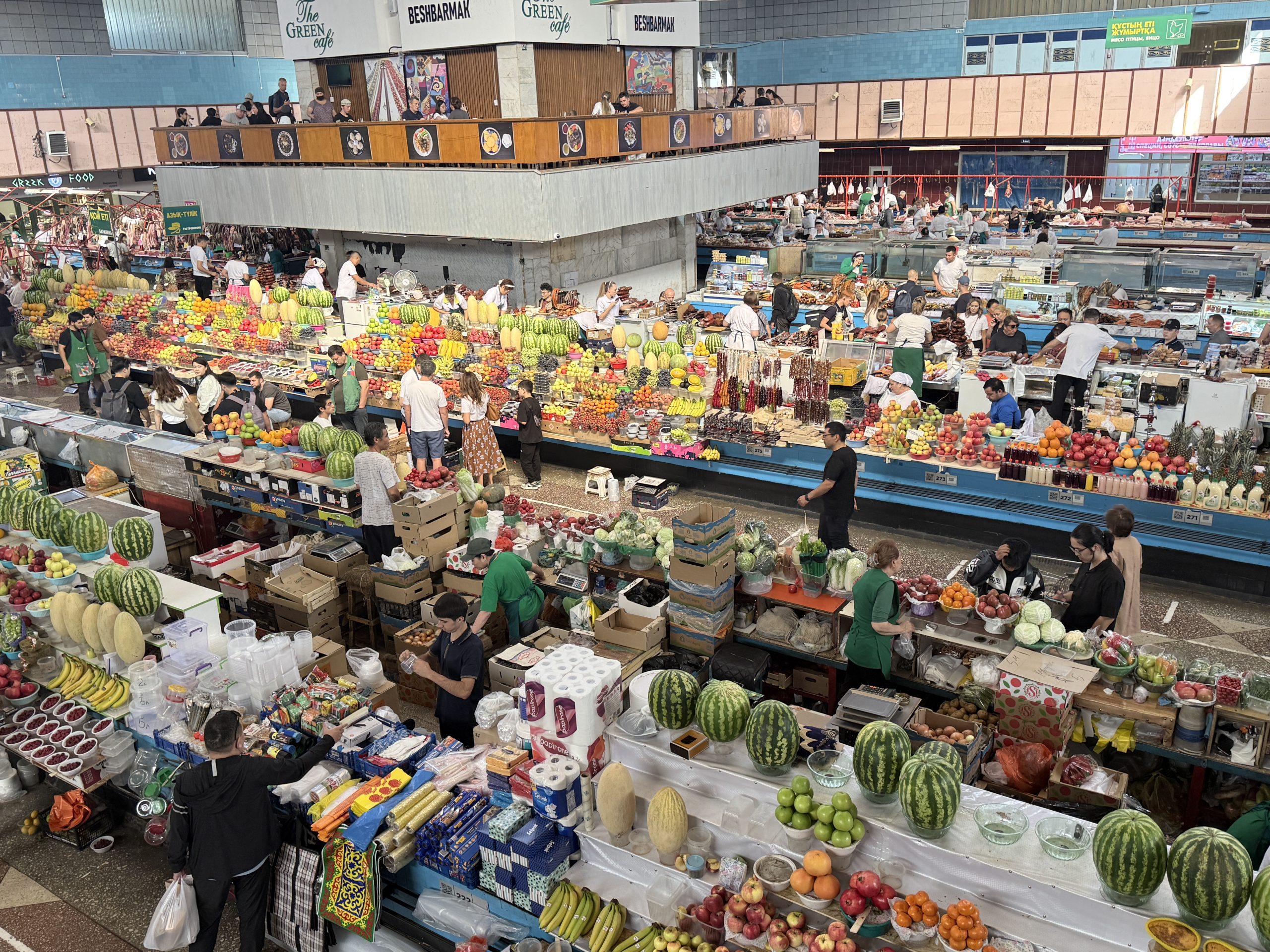
Green Bazaar
You can find local specialties such as kurt (dried cheese balls), horse sausage, fresh produce, various kinds of meat, dried fruits, nuts, and spices all under one roof. The market is worth a visit just for its sheer size. It felt like a museum of food; everything there was so fresh and abundant. We saw huge sections of vegetables, dried spices, and meat. Mostly women are selling the products.
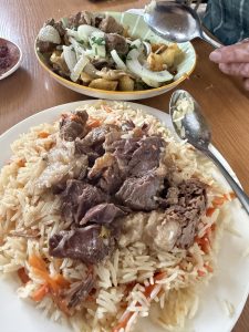
Our Lunch at the Bazaar
Upstairs, you’ll also find many restaurants offering meals at very reasonable prices. We enjoyed the best Uzbek pilaf and lamb skewers, along with their signature fermented horse milk drink and tea. It’s a great place to spend half a day—start with breakfast, then have lunch there to escape the city’s heat. Even in early October, when we visited, it was still quite hot, so this was the perfect spot to relax.
Day and Overnight Trips from Almaty
Charyn Canyon and Kolsai Lake National Park at Kegen District, Almaty Region
How to get There
We rented a 4*4 jeep with a driver through a Facebook group. We used that tour guide plus driver for two trips—one to Charyn Canyon, including Kolsai Lake National Park, and another to Tamgaly Petroglyphs.
How Long was the Drive?
Our driver picked us up around 8 a.m. from our Airbnb in Almaty, and we set off toward Charyn Canyon. It is located about 200 km (120 miles) east of Almaty, near the Kazakh–Chinese border. It’s about a three-hour drive, and the views along the way were pretty cool, lots of open land, rugged terrain, windy roads, small villages, and cemeteries in the middle of nowhere.
The canyon is approximately 154 km (96 miles) long, it is part of the Charyn National Park, recently established on February 23, 2004. Charyn Canyon is often called Kazakhstan’s Grand Canyon, and you can see why. Unlike most canyons around the world, such as the Grand Canyon, which were carved by millions of years of water and wind erosion, Charyn Canyon was primarily formed by deep underground tectonic activity. Tectonic plate movements caused the land to crack, shift, and sink, resulting in the deep gorges and dramatic cliffs that we see today. This process began over 45 million years ago, during the Ordovician period, making the rocks among the oldest in the region.
One of the most iconic sections of Charyn Canyon is the Valley of Castles. Here, wind and water erosion have sculpted the exposed rock into towering formations that resemble ancient fortresses, hence the name.
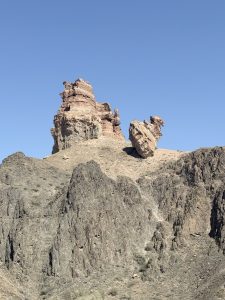
One of the amazing rock formations
The red rock formations are massive and look like ancient castles. The rock formations were incredible, and walking down the trail into the Valley of Castles felt like stepping onto another planet. Honestly, after seeing Moon and Mars Valley in the Atacama Desert and the Grand Canyon in Arizona, we didn’t expect Charyn Canyon to impress us, but it really did.
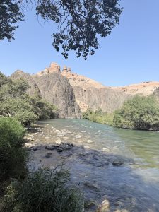
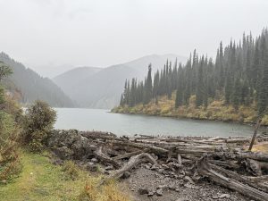
River that carved the canyon
If you keep walking along the marked trail through the canyon, you’ll eventually reach the river that carved it, with clear blue water and trees all around. It was the perfect spot to relax, eat lunch, and enjoy the peace. It’s not as famous as other places we’ve visited, but the landscape was just as stunning—raw, quiet, and full of character. And the best part? Not many tourists.
After visiting Charyn Canyon, we continued driving and stopped at two nearby spots: Black Canyon and White Canyon. These were more like scenic viewpoints than hiking destinations. We got out of the car, walked around a bit, and took some photos. The views were beautiful, but there wasn’t much hiking involved.
We noticed only a few tourists there, probably because most tour groups stick to Charyn Canyon and don’t include this site in their itineraries. It felt nice to have the place almost to ourselves — quiet, open, and peaceful.
In the evening, our driver dropped us off at the homestay we’d rented in the village named Saty. It’s a quiet little place nestled close to Kolsai Lake National Park, in the Kegen District of Almaty Region. After a long day exploring the canyons, arriving in Saty felt good surrounded by mountains, fresh air, and that cozy village vibe. Perfect spot to rest up before heading to the lakes the next day.
Saty Village: What to Expect
Saty is a small village, so don’t expect a lot of accommodation options. There’s one hotel, a few homestay-style places that feel more like hostels, and some yurts. Our homestay was actually a cozy little cabin made from a cargo container — basic but comfortable.
There are only a few restaurants in the village, and most of them serve Uyghur-Chinese food. The one we went to didn’t serve alcohol, so we grabbed some beers from one of the small local markets nearby. It’s a quiet place, but it has everything you need for a short stay before heading to Kolsai Lake National Park. Tourism in Saty is just starting to take off, and it looks like the village is on its way to becoming a popular destination. We saw a lot of construction happening nearby, rows of rustic huts and other tourist-friendly infrastructures being built just a few blocks from where we stayed. It’s still quiet for now, but you can tell things are changing fast. In a few years, this place might look very different.

A Russian-built 4×4 vehicle that you will find all around the village of Saty.
How Far is the Lake from Almaty? How to Reach Lake Kaindy?
The next morning, at about 7:00 pm, our driver picked us up, as it was a long day visiting three lakes, hiking for five hours, and then driving back to Almaty.
Note: Kaindy Lake is situated approximately 280 kilometers from Almaty, and the journey typically takes 4 to 5 hours by car, depending on road conditions.
The Kolsai Lakes National Park is famous for three prominent alpine lakes, often referred to as the “Blue Necklace of Tien Shan.” The two most visited lakes in the Kegen District are Kolsai Lake 1 (Lower Kolsai) and Kaindy Lake. Some people first go to Kolsi Lake and then Kaindy Lake and do this as a day trip from Almaty. We stayed at Saty village because we wanted to hike from the first Kolsi lake to the second Kolsi lake, which is about a five to six-hour round-trip hike.
How to Reach the Lake?
Our first stop was Kaindy Lake. The driver dropped us at the parking lot, where we had to wait for a 4×4 shuttle to take us further. There were several rugged Russian jeeps, such as the UAZ Hunter and UAZ Patriot, commonly used for off-road trips in this region. These vehicles are designed to navigate rough terrain and are often included in local tour packages. Once the jeep filled up with about seven to nine passengers, it took us on a short but bumpy 15-minute ride across dirt roads and small water creeks to the trailhead.
Kaindy Lake view from the top
From there, it’s a short walk to the lake viewpoint.
Alternatively, you can skip the jeep and either walk or ride a horse—each option has its own trail. On our way back, we chose to walk instead of taking the jeep and followed the horse trail, which was wider and quicker. There weren’t many horses on the path, so it was a peaceful walk back to the parking lot, where our driver was waiting.
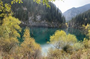
About the Kaindy Lake
Kaindy Lake is a beautiful mountain lake in southeastern Kazakhstan, near Saty village. It’s about 400 meters long and 30 meters deep, sitting 2,000 meters above sea level. The lake was created in 1911 after a big earthquake caused a landslide that blocked a river and formed a natural dam.
What makes Kaindy Lake special is the sunken forest. Tall spruce trees still stand in the water, and because the lake is so cold, the tree trunks haven’t rotted. The water has a bright turquoise color, especially in autumn when the trees around the lake turn golden and reflect in the water. It’s a great time to visit.
There’s a short staircase hike cum walk that takes you to a viewpoint above the lake. If you want to get closer to the water, you can follow a trail down, but you’ll need to cross a small stream to reach the lake’s edge. The lake is also known for trout fishing and even ice diving in winter.
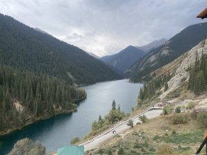
Kolsai Lake 1 (Lower Kolsai)
This is the most accessible and largest of the three Kolsai lakes.
About the Kolsai Lake
It’s set within a peaceful conifer forest, surrounded by stunning mountain scenery. The shimmering blue waters are ideal for non-motorized activities.
Hikes and Views
Deck Walk: There is a wooden deck walk with multiple viewpoints along the lake. This is a straightforward and accessible path that offers beautiful views with minimal effort. We saw many yurts and huts near the lower lake, providing options for overnight stays. Staying overnight allows you to enjoy the tranquility of the park during night and ealy day before the day-trippers arrive.
Kolsai Lake I Stair Deck
Kolsai 2 (Mynzholky), hike
For a longer, more rewarding hike, you can trek from Kolsai Lake 1 to Kolsai Lake 2. This is a moderately difficult trail that takes several hours (approximately 5–6 hours round trip) and gains some elevation. When we were there, it was raining, which made our hike a little challenging because of the slippery mud on the trail. Most of the route winds through the forest, and the many tree roots became quite slick when wet. Despite the challenge, the whole hike was rewarding, offering views of the huge First Kolsai Lake. You first see the inlet where water flows in from the Second Kolsai Lake, which soon appears before you.
Secondly, we did not see the turquoise color of the lake; due to the overcast sky, the water had turned grayish. It was also chilly, so we did not wait for the rain to stop and the sun to come out—which actually happened just as we were returning to the end of the hike.
Kolsi Lake 2
Actually, there is a third lake, Kolsai 3, but we did not hike to that one as we were getting late to go back to Almaty, and the rainy weather also did not permit us to do that. The full trek to the third lake from Kolsai 1 would have made the total hike approximately 14 km one way.
We started our hike from Kolsai Lake One to Kolsai Lake Two at about noon and completed our hike in a little over five hours, with a fifteen-minute break at Kolsai Lake Two. We reached back to the parking lot, where our driver was waiting for us, at about 5:30 p.m. We drove back without taking any breaks and reached Almaty at ten o’clock at night.
The next morning, we stayed in Almaty, and the following day, the same driver picked us up at 7:00 from our Airbnb place for the Tamgaly Petroglyphs and Nomad’s Palace (also known as the City of Nomads).
Tamgaly-Tas Petroglyphs: Ancient Buddhist Art on the Ili River
Tamgaly Petroglyphs – A UNESCO World Heritage site, where Bronze Age rock carvings depict sun gods, hunters, and animals. It’s a fascinating place to look into Central Asia’s ancient culture. The most important art is the depiction of Bodhisattva Avalokiteshvara with four hands seated on a lotus throne. Later, figures such as Buddha Shakyamuni and healing deities were added. Tibetan historical background. Below is a brief summary of its background, origin, and religious significance:
Name & Origin: Tamgaly-Tas means “Painted Rocks” or “Stones with Signs.” Carvings date to the 17th century, when Dzungar Lamaism was widespread in South-East Kazakhstan.
Creators: Oirat and Tibetan masters, led by Galdan Boshugtu Khan, who was deeply religious and skilled in Buddhist symbolism.
Iconography: In 1677, the first major carving mantras such as “Om Mani Padme Hum” are inscribed.
Political Significance: After the Dzungars were expelled, Kazakh leaders Ablai Khan and Sultan Abulfeiz marked the rocks with their tamga (tribal signature), confirming Uysun and Naiman ownership of the land.
Later History: The last inscription dates to 1771, left by the Volga Kalmyks. From the 19th century onward, scholars such as Ch. Ch. Valikhanov (1856) and others documented the site.
Cultural and Artistic Importance: There are 18 inscribed rocks spread across 15 scattered blocks. They are fine, contour stone carving with large-scale Buddhist images unique to Central Asia. This is a vivid example of Buddhism’s spread along the Silk Road and cross-cultural exchanges in Central Asia.
Note: Do not confuse Tamgaly-Tas (Buddhist, 17th century) with Tanbaly (UNESCO site, Bronze Age petroglyphs).
Local legend holds that an earthquake caused boulders to fall and form a natural river crossing, which pilgrims saw as divine intervention. The rocks were then consecrated with Buddhist images.
Location, Access and Vehicle
It is about 120 km north of Almaty (about 1.5–2 hours drive).
Drive via Kapchagai highway, cross the Ili River bridge. Turn toward Bakanas, then onto a dirt steppe road (~15 km). Look for Chinese-style gates and tall cliffs.
An SUV or 4×4 vehicle is recommended, especially in wet weather. Also, it’s better to get a local driver who knows how to drive on rugged mountain paths.
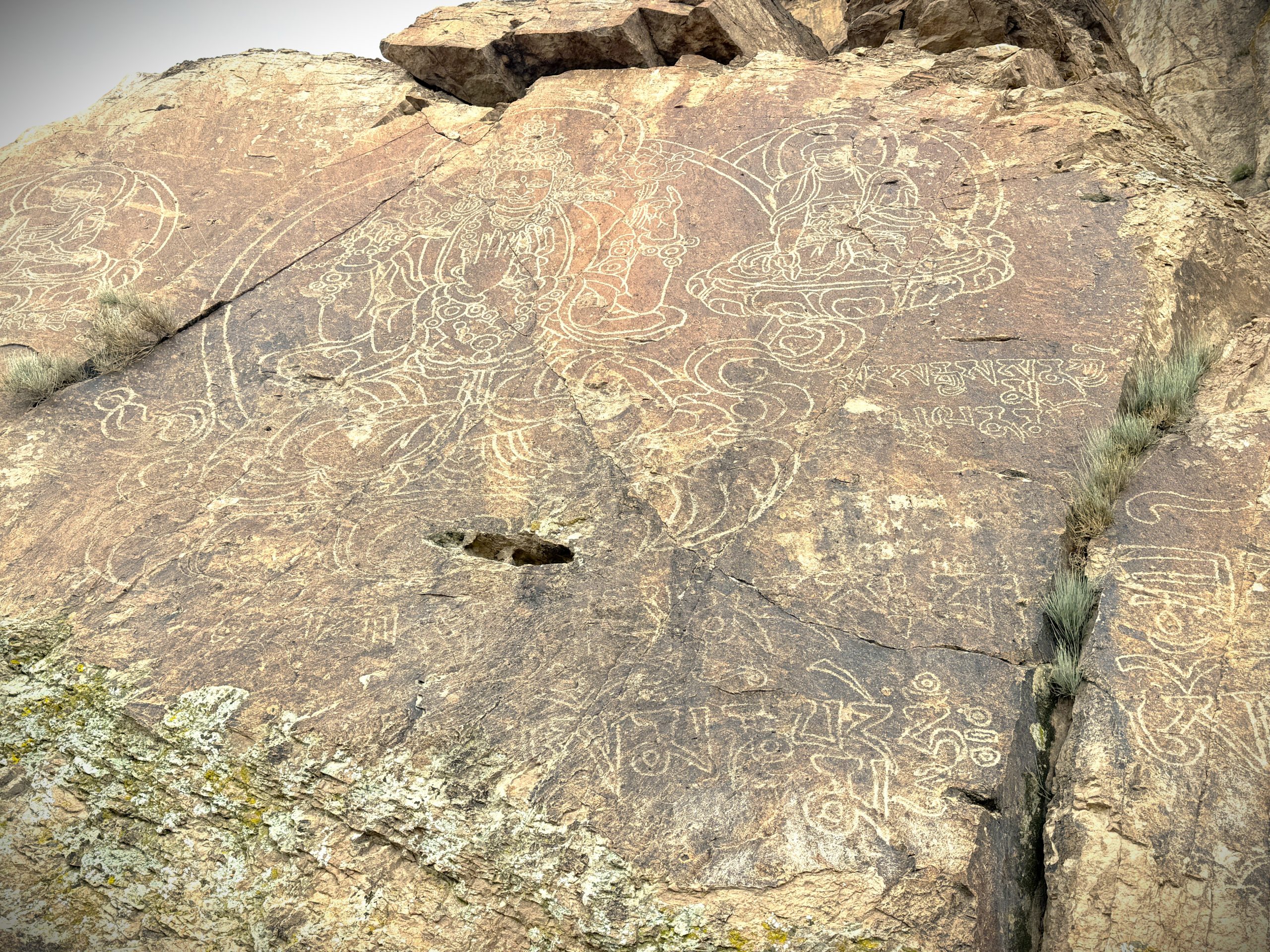
Buddha Shakyamuni and healing deities
Visitor Experience
This place sits on the banks of the Ili River, surrounded by cliffs about 60 meters high. It feels calm and spiritual, almost like an open-air temple, with a strong connection to the old Silk Road. You can explore the petroglyphs in about two to three hours, and the best time to see them is in the afternoon light. Visitors can also take walks along the river, go hiking, camp, or try rock climbing, which has been popular here since the 1970s.
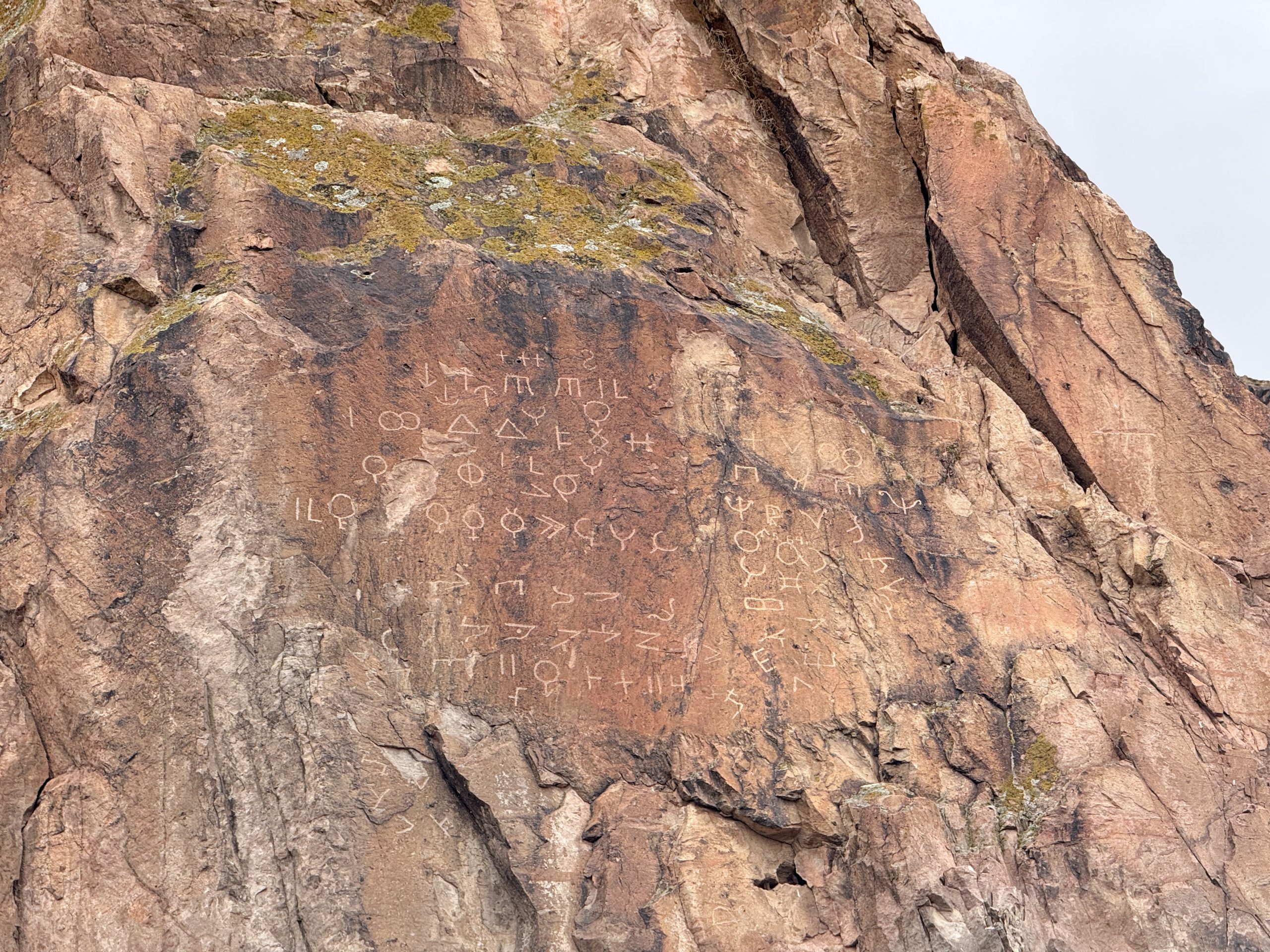
Ancient Language on one of the Rocks
City of Nomads (A Nearby Attraction)
While visiting Tamgaly-Tas, you can see some building structures across the Ili River—that is the City of Nomads. Unfortunately, you can’t walk across the river, as there’s no bridge connecting the two sides. To get there, visitors must drive around, which takes about forty-five minutes on a rough dirt road.
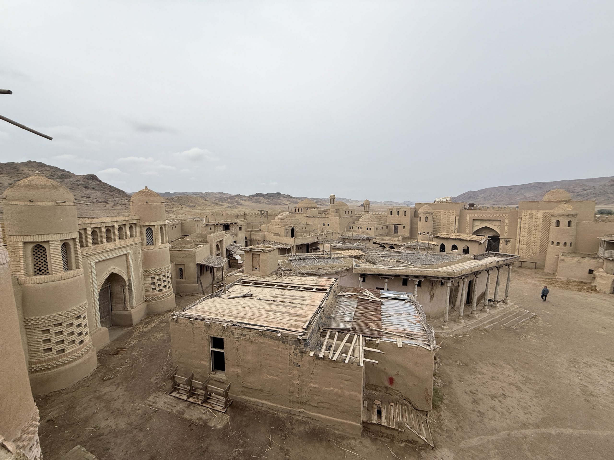
City of Nomads, a Silk Road caravanserai replica, 11-14th Century
The City of Nomads is a fortress built in 2004 for the Kazakh-French film Nomad: The Warrior. It was designed in a caravanserai style, featuring fortress gates, towers, a mosque, and medieval-style houses. The site is a replica of a typical ancient fortress and gives visitors a glimpse of what life might have looked like centuries ago. You’ll be amazed by the attention to detail put into creating this replica. The entrance fee is about 1,000 tenge, and it’s often included in Tamgaly-Tas tours.
A large-scale historical television drama depicting the tumultuous events leading to the formation of the Kazakh Khanate in 1465 was also filmed at this location.
Practical Tips
- There are no facilities on-site once you leave the city limits. Bring your own water, snacks, and supplies.
- Toilets: Basic pit toilets. Bring sanitizer and wipes.
- No cell signal near the river.
- Best Time: Spring, fall, or winter. Avoid summer heat and rainy days.